River systems, as critical agents shaping landscapes and vital water resources for human survival, undergo drainage reorganization under tectonic and climatic influences. This process not only explores mechanisms of basin geomorphic evolution but also holds significant implications for scientific river management, making it a key focus in both theoretical geoscience and engineering applications. While studies on superimposed river reorganization have largely achieved mutual validation between geological evidence and conceptual models, the drainage reorganization of antecedent rivers responding to coupled tectonic activity and climate change remains at the conceptual modeling stage, lacking empirical validation from tectonic marginal zones.A research team led by Prof. Pan Baotian and Prof. Hu Zhenbo from Lanzhou University innovatively integrated geomorphic, sedimentary, and provenance records. Using cosmogenic nuclides, optically stimulated luminescence (OSL), and 14C-AMS cross-dating, they systematically reconstructed the drainage reorganization process of north-south trending antecedent rivers traversing the Jiudong Basin in the northeastern margin of the Tibetan Plateau.
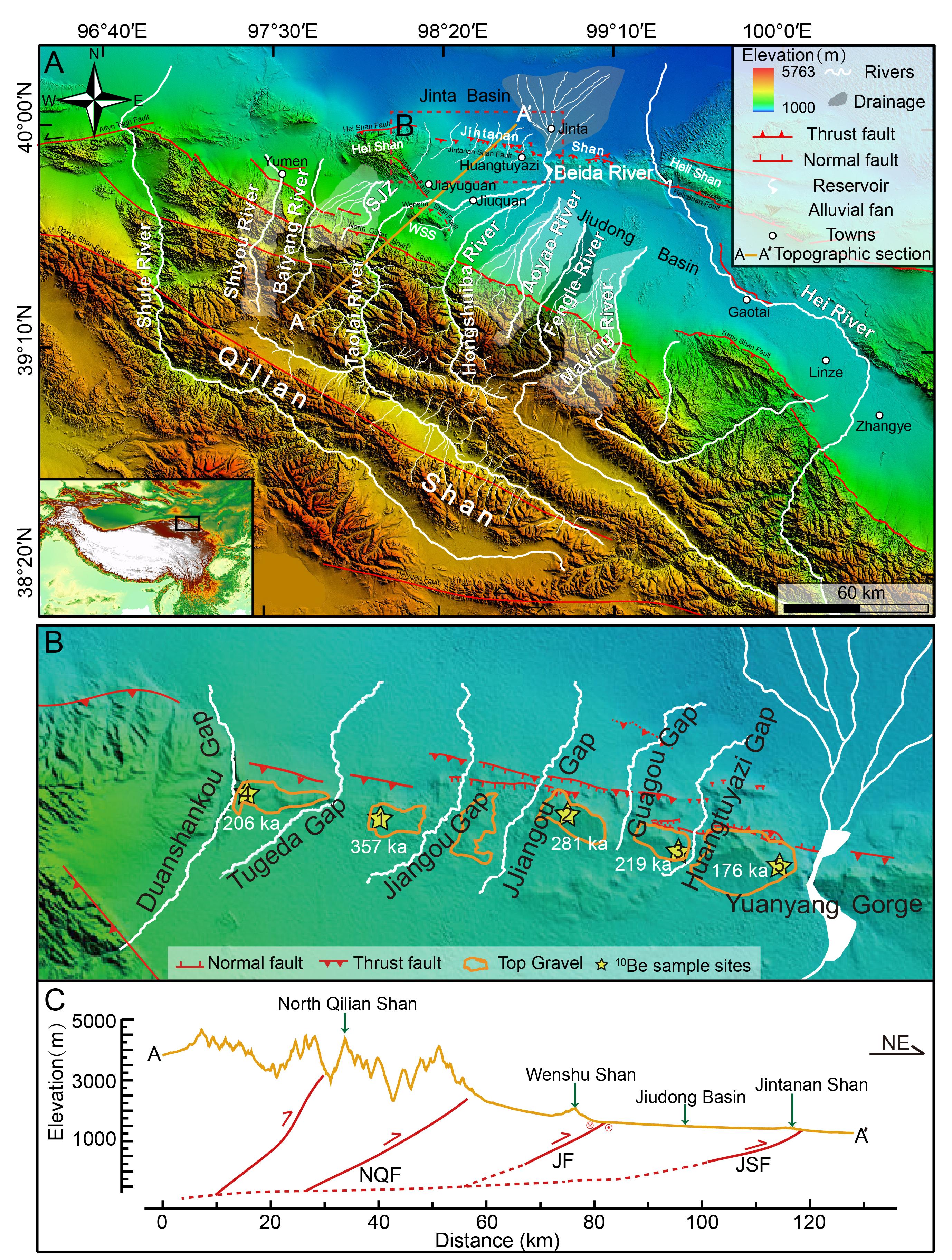
Figure 1: Tectonic and Geomorphic Map of the Jiudong Basin
The Jiudong Basin, a representative active tectonic zone on the northeastern margin of the Tibetan Plateau, is bounded by the Qilian Mountains to the south and the uplifting Jintanan Mountains to the north, forming a basin-range landscape. Rivers originating from the northern Qilian Mountains, as antecedent rivers, cut through the Jintanan Mountains, developing seven wind gaps and fluvial terrace sequences. The team systematically studied these terrace sequences, tectonic deformation patterns, formation ages, and provenance of overlying fluvial sediments. Key findings include: 1):The Jintanan Mountains, the outermost northeastern extension of the Tibetan Plateau, exhibit detachment and fault-bend folding deformation. Segmented east-west mountain uplift began ~360,000 years ago;2): The segmented uplift confined dispersed drainage systems from the northern Qilian Mountains, forming independent north-flowing rivers: the Shuangjingzi, Taolai, and Hongshuiba Rivers;3):In response to tectonic uplift, these rivers underwent reorganization through incision, diversion, and eventual confluence, forming the unified modern Beida River to traverse the rising mountains;4): River incision and terrace formation coincided with climate transitions from interstadial to glacial periods, while river diversion and wind gap abandonment occurred during colder glacial phases coupled with intense tectonic uplift. This reveals that antecedent river reorganization in tectonic marginal zones is driven by rapid uplift coupled with cold-dry climatic shifts.
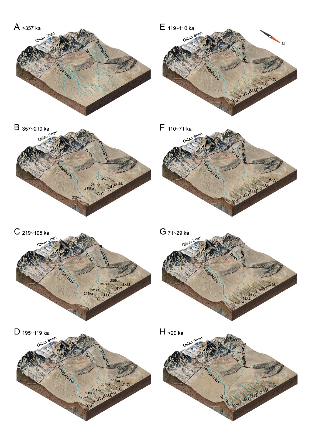
Figure 2: Schematic Model of Antecedent River Drainage Reorganization
This study not only provides geological evidence for antecedent river reorganization in response to young mountain uplift along the active tectonic margin of the northeastern Tibetan Plateau but also demonstrates the absence of temporal lag in this process. This advances the long-debated understanding of chronological relationships between landscape evolution and river development.
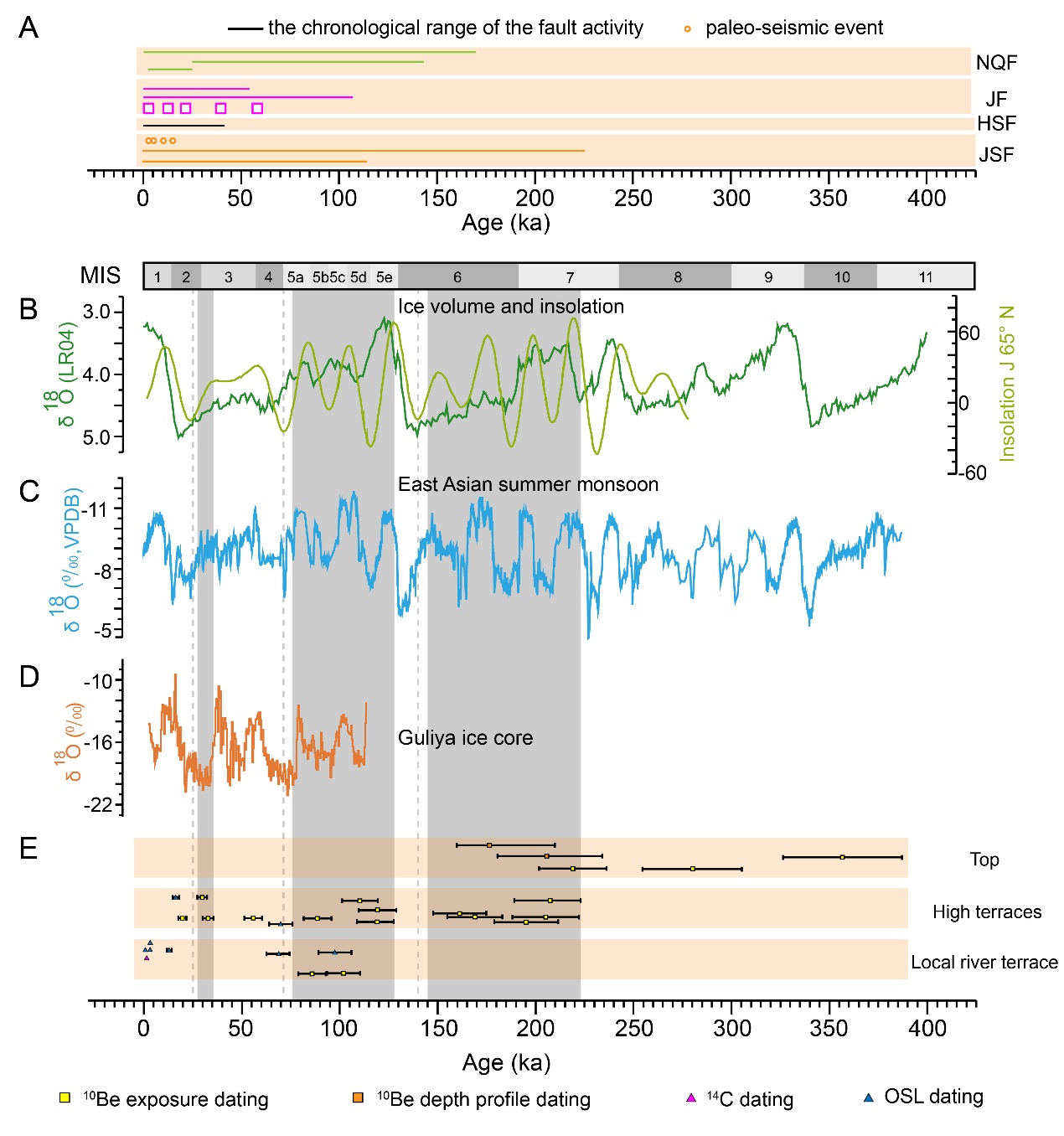
Figure 3: Comparison of River Incision/Wind Gap Abandonment Ages with Regional Tectonic Activity and Climate Records
The study, titled“Reorganization of antecedent rivers in response to the evolving landscape at the northeastern margin of the Tibetan Plateau”, was published as a review article in the prestigious geoscience journalEarth-Science Reviews(IF: 10.8). Prof. Pan Baotian from the School of Earth and Environmental Sciences, Lanzhou University, is the first author, with Prof. Hu Zhenbo and PhD candidate Dong Zijuan as corresponding authors. The research was supported by the National Natural Science Foundation of China (Grant No. 41730637).
Paper Link: https://doi.org/10.1016/j.earscirev.2025.105153
