Against the backdrop of deep integration between mobile internet and Artificial Intelligence, NIAN Yanyun's Research Team from Department of Information Geography has conducted systematic research on human activity identification based on a "multi-temporal scale + multi-data source" framework. Using Tencent Location Request (TLR) data as the core, and integrating trajectory, land use, and social media check-in data, the team constructed a spatiotemporal analysis chain ranging from intra-day to interannual scales.
Taking the Qilian Mountains National Park (under preparation) as an example, the team used TLR data to build hourly time series, combined STL time-series decomposition with K-means clustering, and overlaid 2bulu GPS trajectory and land use data to identify two typical local human activity patterns: a resident daily pattern characterized by a distinct nighttime peak and a high proportion of cultivated and built-up land, and a tourism activity pattern marked by daytime-only activity, few nighttime location requests, and dense tourist trajectories. The results provide a scientific basis for local tourism season management.
In another study extended to the entire Qinghai-Tibet Plateau, the team resampled Tencent Location Request data and conducted clustering at both daily and annual scales, extracting three intra-day patterns (daily, mobility, and dispersed residential) and two interannual patterns (urban and rural). The daily areas show clear midnight peaks and are significantly associated with high proportions of cultivated and built-up land; mobility areas lack nighttime peaks and are strongly related to tourist trajectories; and dispersed residential areas are widely distributed above 3,500 meters in elevation. On an annual scale, the spatial distribution of urban patterns corresponds closely with built-up city areas, and the opposite seasonal fluctuations of the urban/rural modes during the Spring Festival (February) reflect population migration between cities and rural areas. This multi-scale framework quantitatively reveals the altitudinal differentiation and complex urban-rural/pastoral-tourism pattern of human activities on the plateau, providing an operational data solution for refined human activity management and ecological carrying capacity monitoring.
In another line of research, the team focused on the unique advantages of social media text data for environmental perception and pollution event localization. They proposed a multi-model framework combining "iterative keyword library + RoBERTa-based topic/sentiment classification + BERT-BiGRU-CRF named entity recognition". Through an iterative "acquire-classify-extract-update" process, they built a Weibo environmental keyword library containing 1,019 terms, collected 47,737 theme-related posts, and performed geographic coding of place names. The F1-scores for topic classification, sentiment analysis, and keyword extraction reached 0.90, 0.80, and 0.87, respectively. Results showed that negative emotions were most prominent in cities like Beijing and Chengdu, while the Shandong-Jiangsu region maintained consistently positive sentiment. A case study of a water pollution event further demonstrated the framework's capability in rapidly identifying event locations and tracing the spatiotemporal diffusion of public opinion. These innovative applications of social media and location-based data have significantly improved the spatiotemporal resolution of human activity research, complemented the limitations of traditional remote sensing methods, and provided valuable methodological and practical insights for policy-making.
The research findings have now been published in leading journals in the field of information geography International Journal of Digital Earth (JCR Q1) and Geo-Spatial Information Science (JCR Q1). Che Minglu, a master's student in Cartography and Geographic Information System at the College of Earth and Environmental Sciences, Lanzhou University (currently a research assistant at the Institute of Tibetan Plateau Research, Chinese Academy of Sciences), is the first author. Prof. NIAN Yanyun served as the corresponding author, and Prof. PEI Tao (Researcher at the Institute of Geographic Sciences and Natural Resources Research, CAS, and adjunct professor at Lanzhou University) is a co-author. The research was supported by the National Tibetan Plateau Data Center.
Paper Links:
https://doi.org/10.1080/17538947.2023.2259926
https://doi.org/10.1080/17538947.2025.2543570
https://doi.org/10.1080/10095020.2025.2541877
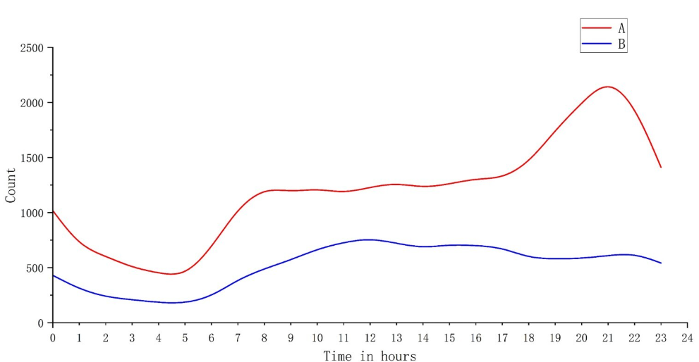
Figure 1. Different population activity patterns.
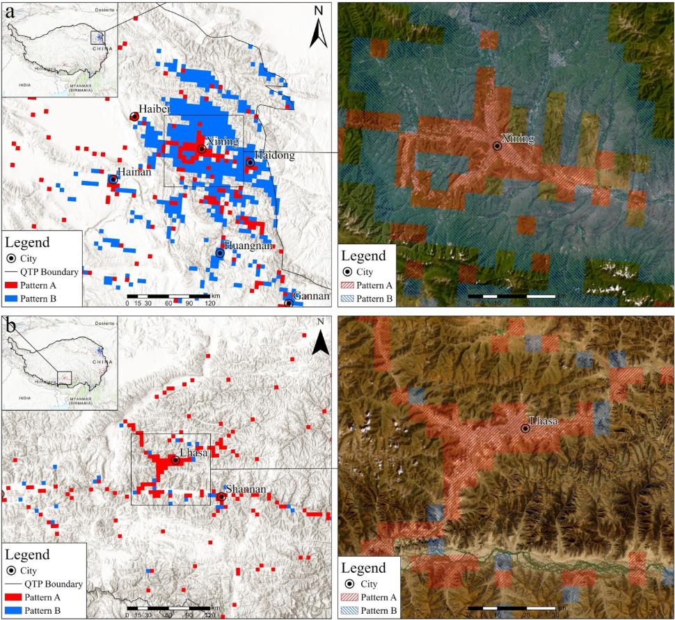
Figure 2. Comparison of annual pattern distributions and remote sensing images near Xining (a) and Lhasa (b).
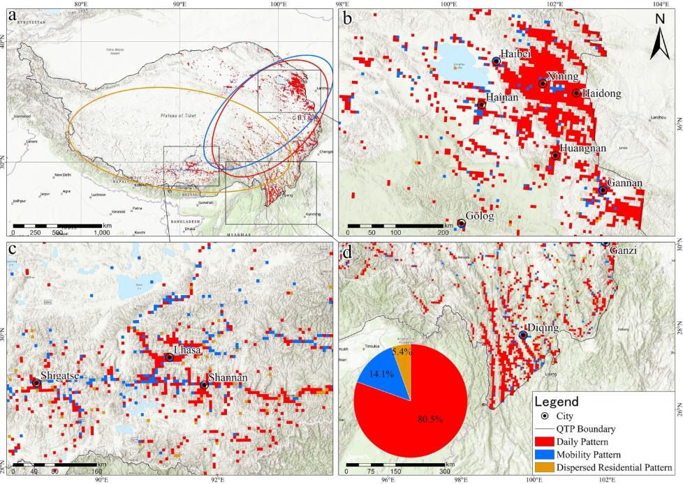
Figure 3. Distribution of daily human activity patterns.
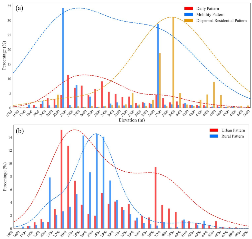
Figure 4. Altitude distribution and probability density curves of different modes in the daily patterns (a) and annual patterns (b).
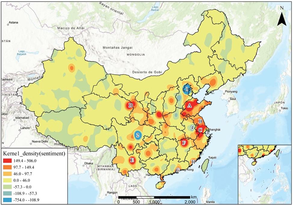
Figure 5. Sentiment kernel density estimation plot for environmental issues.

Figure 6. Word cloud of environmental themes.
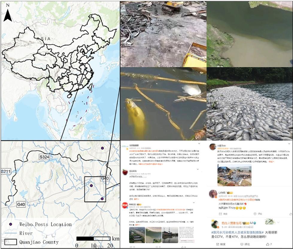
Figure 7. Weibo posts illustrating pollution in the Chuhe River.
